(well maybe)
I've been as confused as the next man by the new road layout that seems to have taken as long as the stadium to build. Great pics from Jack but no idea where they are or what they are showing.
Went and had a look at the planning app drawings (via http://www.brighton-and-hove.co.uk) (link towards the bottom - it's called "Master Plan - Proposed") and it has become a lot more clear. You can see the road in great detail on the drawings.
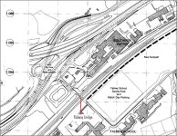
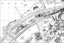
I've copied a couple of parts of the road layout plan below.
The bottom image shows the new road layout in relation to the stadium. The new layout is shown bottom left of the image. It's just to the South of the bypass and next to Southern Water. At the bottom of the image you can see the field that will be used for match day parking. This road scheme appears to be all about getting people in and out of this parking area.
The top image image is more close-up. Coming almost diagonally across the image from top right to bottom left is the A270.
Coming from Lewes, the new road junction will allow drivers to fork left as if heading in to Brighton and then bear left down to a junction where they turn left past the southern end of Southern Water and then across the railway bridge to the parking. To go back to Lewes after a game this traffic leaves the car park, over the railway and carries on under the A270 (main road into Brighton) then loops round and joins the main road heading to Lewes.
The big square arch/bridge that Jack has been photographing is this bit of road where drivers will go under the main road and then loop back north to join the A27.
Coming from Brighton on the A270, it look like you will stop at a new junction by the new arch then turn right under the new arch (and under the Southbound A270) and then past the southern end of Southern Water and over the railway bridge. To go back to Brighton you'll come out of the car park, over the railway bridge, past the bottom end of Southern Water and then turn left onto a slip road that will merge with the A270 into Brighton.
Hope that's a bit more clear. References to the railway bridge are a guess - it's hard to see on the plan - road may in fact go under the railway to get access to the playing fields/match day parking, but you get the point.
I've been as confused as the next man by the new road layout that seems to have taken as long as the stadium to build. Great pics from Jack but no idea where they are or what they are showing.
Went and had a look at the planning app drawings (via http://www.brighton-and-hove.co.uk) (link towards the bottom - it's called "Master Plan - Proposed") and it has become a lot more clear. You can see the road in great detail on the drawings.
I've copied a couple of parts of the road layout plan below.
The bottom image shows the new road layout in relation to the stadium. The new layout is shown bottom left of the image. It's just to the South of the bypass and next to Southern Water. At the bottom of the image you can see the field that will be used for match day parking. This road scheme appears to be all about getting people in and out of this parking area.
The top image image is more close-up. Coming almost diagonally across the image from top right to bottom left is the A270.
Coming from Lewes, the new road junction will allow drivers to fork left as if heading in to Brighton and then bear left down to a junction where they turn left past the southern end of Southern Water and then across the railway bridge to the parking. To go back to Lewes after a game this traffic leaves the car park, over the railway and carries on under the A270 (main road into Brighton) then loops round and joins the main road heading to Lewes.
The big square arch/bridge that Jack has been photographing is this bit of road where drivers will go under the main road and then loop back north to join the A27.
Coming from Brighton on the A270, it look like you will stop at a new junction by the new arch then turn right under the new arch (and under the Southbound A270) and then past the southern end of Southern Water and over the railway bridge. To go back to Brighton you'll come out of the car park, over the railway bridge, past the bottom end of Southern Water and then turn left onto a slip road that will merge with the A270 into Brighton.
Hope that's a bit more clear. References to the railway bridge are a guess - it's hard to see on the plan - road may in fact go under the railway to get access to the playing fields/match day parking, but you get the point.