You are using an out of date browser. It may not display this or other websites correctly.
You should upgrade or use an alternative browser.
You should upgrade or use an alternative browser.
[Misc] The Award-winning official "More Snow Tomorrow?" Thread [2024-25 Season]
- Thread starter Giraffe
- Start date
More options
Who Replied?Papa Lazarou
Living in a De Zerbi wonderland
Ok, heads up.
I previously hinted at a possibly cold spell at the end of the 1st week of February. Well the data is starting to firm up on the possibility of an Easterly or North Easterly setting up over the UK from 5/6 February.
It's still a long way off, but there is support for it in all of the models, and if it occurs we'd be tapping into colder air than was available last time, so we'd expect any precipitation to be more snow than rain.
Details are not possible yet, as we're still over a week away, and timings vary.
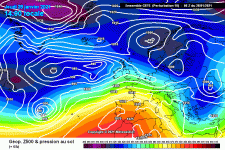
The GIF below shows how we would get there, with a series of low pressures getting squeezed and elongated near the UK, beneath an Arctic High, and eventually pushed into Europe, allowing High Pressure to build to our North, and open the gates.
The 2nd chart is from today's GFS (other models show similar) and shows the cluster of cold runs in the ensemble, showing reasonable (if not total) support for a cold week from the 6th or 7th Feb.
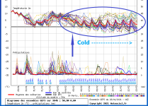
(Warning - there ARE milder runs still in the mix, but currently 60-70% of the runs support this)
Snow row values should be taken as a guide only, for now.
So, maybe, just maybe ❄☃
I previously hinted at a possibly cold spell at the end of the 1st week of February. Well the data is starting to firm up on the possibility of an Easterly or North Easterly setting up over the UK from 5/6 February.
It's still a long way off, but there is support for it in all of the models, and if it occurs we'd be tapping into colder air than was available last time, so we'd expect any precipitation to be more snow than rain.
Details are not possible yet, as we're still over a week away, and timings vary.
The GIF below shows how we would get there, with a series of low pressures getting squeezed and elongated near the UK, beneath an Arctic High, and eventually pushed into Europe, allowing High Pressure to build to our North, and open the gates.

The 2nd chart is from today's GFS (other models show similar) and shows the cluster of cold runs in the ensemble, showing reasonable (if not total) support for a cold week from the 6th or 7th Feb.

(Warning - there ARE milder runs still in the mix, but currently 60-70% of the runs support this)
Snow row values should be taken as a guide only, for now.
So, maybe, just maybe ❄☃
Could it sound a bit like a...Feast from the Least?
Papa Lazarou
Living in a De Zerbi wonderland
Could it sound a bit like a...Feast from the Least?
Ceased from the Yeast
Mellor 3 Ward 4
Well-known member
I'm normally all over the 'snow' thread, but with 50+ million people to vaccinate, including at the moment lots of oldies who may struggle to travel, it can do one this year.
#killjoy
#killjoy
Ok, heads up.
I previously hinted at a possibly cold spell at the end of the 1st week of February. Well the data is starting to firm up on the possibility of an Easterly or North Easterly setting up over the UK from 5/6 February.
It's still a long way off, but there is support for it in all of the models, and if it occurs we'd be tapping into colder air than was available last time, so we'd expect any precipitation to be more snow than rain.
Details are not possible yet, as we're still over a week away, and timings vary.
The GIF below shows how we would get there, with a series of low pressures getting squeezed and elongated near the UK, beneath an Arctic High, and eventually pushed into Europe, allowing High Pressure to build to our North, and open the gates.
View attachment 133118
The 2nd chart is from today's GFS (other models show similar) and shows the cluster of cold runs in the ensemble, showing reasonable (if not total) support for a cold week from the 6th or 7th Feb.
View attachment 133119
(Warning - there ARE milder runs still in the mix, but currently 60-70% of the runs support this)
Snow row values should be taken as a guide only, for now.
So, maybe, just maybe ❄☃


Our forecast for Saturday


Brighthelmstone
Well-known member
Bring on the snow! 
I'm normally all over the 'snow' thread, but with 50+ million people to vaccinate, including at the moment lots of oldies who may struggle to travel, it can do one this year.
#killjoy
I'm sort of with you, although obviously snow does prevent people travelling to spread the virus so it's not 100% negative. Plus encourages people to go outside (locally), which is never a bad thing.
Plake
Unregistered User
I'm normally all over the 'snow' thread, but with 50+ million people to vaccinate, including at the moment lots of oldies who may struggle to travel, it can do one this year.
#killjoy
As somebody who normally hopes for snowmageddon I’m surprised to find myself totally agreeing with you.
- Aug 8, 2005
- 27,227
- Thread starter
- #15,511
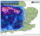
Such a depressing picture that one. Interesting but very depressing. So near, and yet so far away.
- Aug 8, 2005
- 27,227
- Thread starter
- #15,512
Ok, heads up.
I previously hinted at a possibly cold spell at the end of the 1st week of February. Well the data is starting to firm up on the possibility of an Easterly or North Easterly setting up over the UK from 5/6 February.
It's still a long way off, but there is support for it in all of the models, and if it occurs we'd be tapping into colder air than was available last time, so we'd expect any precipitation to be more snow than rain.
Details are not possible yet, as we're still over a week away, and timings vary.
The GIF below shows how we would get there, with a series of low pressures getting squeezed and elongated near the UK, beneath an Arctic High, and eventually pushed into Europe, allowing High Pressure to build to our North, and open the gates.
View attachment 133118
The 2nd chart is from today's GFS (other models show similar) and shows the cluster of cold runs in the ensemble, showing reasonable (if not total) support for a cold week from the 6th or 7th Feb.
View attachment 133119
(Warning - there ARE milder runs still in the mix, but currently 60-70% of the runs support this)
Snow row values should be taken as a guide only, for now.
So, maybe, just maybe ❄☃
But this gets a MASSIVE thumbs up. I know it's far from certain, it always is, but fingers crossed this is our turn.
LamieRobertson
Not awoke
I'm sort of with you, although obviously snow does prevent people travelling to spread the virus so it's not 100% negative. Plus encourages people to go outside (locally), which is never a bad thing.
But no snow ball fights with the neighbourhood or large fine
LamieRobertson
Not awoke
Our forecast for Saturday

Look forward to scenic photo
Frankie
Put him in the curry
Looks ominous here in Ceredigion, the council have ordered 2 bags of extra salt from the Co Op
Seasidesage
New member
With the advent of WFH and Teams I see nothing going for snow now other than me falling over so no thanks send it to the northerners who like this sort of crap...
Yoda
English & European
The GFS is still going strong with the much colder conditions from next Saturday night. Still a lot can change on that front as the ensembles are all over the place for that period


Papa Lazarou
Living in a De Zerbi wonderland
As [MENTION=1933]Yoda[/MENTION] has said we need the models to stabilise around a solution.
The 'decision' is how the low pressure that sinks into Europe 'behaves'. The Op run above (thick green) takes a while to get a clean easterly flow, so it's a few days behind other runs, which move it quickly over France.
The 'decision' is how the low pressure that sinks into Europe 'behaves'. The Op run above (thick green) takes a while to get a clean easterly flow, so it's a few days behind other runs, which move it quickly over France.
Tom Hark Preston Park
Will Post For Cash
- Jul 6, 2003
- 72,327
What is this 'snow' of which you speak? 

What is this 'snow' of which you speak?
Slowly starting to look like we might miss out again. There's a cold spell coming, but will it be cold enough in the south?

