Got something to say or just want fewer pesky ads? Join us... 😊

[Misc] The Award-winning official "More Snow Tomorrow?" Thread [2024-25 Season]


Eeyore

Colonel Hee-Haw of Queen's Park
NSC Patron
Apr 5, 2014
25,931
According to the BBC, they are still not sure if the very cold air will drift south of the UK, around south of the country, the whole of the country, or even how far West it will reach.

Basically, they don't want to look bad if they get it wrong.

Or they are simply saying that it is impossible to be sure of the weather in a few days time.


Giraffe

VERY part time moderator
Helpful Moderator
NSC Patron
Aug 8, 2005
27,230
Or they are simply saying that it is impossible to be sure of the weather in a few days time.
I think that is a fairer assessment of he situation.

That said, the BBC are certainly towards the conservative and less “need to make a name for myself” end of the forecasting spectrum.


chucky1973

New member
Nov 3, 2010
8,829
Crawley
Papa, I have been a wake now for 2 hours and there is no update. This is not on. Updates need to be every hour all the time the Beast from the East is coming............

If you had work, phone in sick.

We are now whats important.

:)

Its gonna happen. I can feel it, my dog is going to see snow finally!!


Postman Pat

Well-known member
Jul 24, 2007
6,973
Coldean
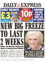
I don't believe anything until the DAILY EXPRESS says so.

Until they quote AccuWeather telling us how awful it will be (and then add a Met Office spokesman suggesting something far more sedate) I won't accept it.

They did.....yesterday! WE ARE ALL DOOMED!!!

Daily Express.PNG


Papa Lazarou

Living in a De Zerbi wonderland
Jul 7, 2003
19,361
Worthing
No real change in the outlook.... there is a fair amount of model 'noise' during next week, but we WILL see some very cold air arriving Sunday night, and from there the air remains very cold, and there will be features in the flow that will generate snow. The details won't be apparent until the weekend probably. After about Wednesday next week there are a few different evolutions possible, from continuation of the easterly flow, to a NE or even a low developing near the UK. Each will bring different temperatures, and snowfall potential.

The latest GFS ensemble shows the potential and variations quite well.

graphe_ens4_omv5.gif


Napper

Well-known member
Jul 9, 2003
24,452
Sussex
No real change in the outlook.... there is a fair amount of model 'noise' during next week, but we WILL see some very cold air arriving Sunday night, and from there the air remains very cold, and there will be features in the flow that will generate snow. The details won't be apparent until the weekend probably. After about Wednesday next week there are a few different evolutions possible, from continuation of the easterly flow, to a NE or even a low developing near the UK. Each will bring different temperatures, and snowfall potential.

The latest GFS ensemble shows the potential and variations quite well.

graphe_ens4_omv5.gif

Just out interest , the precipitations on the right , even the boldest prediction in black from GFS only has it peaking at about 12.5mm on the 5th.

That's just a mere dusting ?

Or am I reading it incorrectly


Papa Lazarou

Living in a De Zerbi wonderland
Jul 7, 2003
19,361
Worthing


Yoda

English & European
Just out interest , the precipitations on the right , even the boldest prediction in black from GFS only has it peaking at about 12.5mm on the 5th.

That's just a mere dusting ?

Or am I reading it incorrectly

mm would be if falling as rain. Rule of thumb is 1mm of rain = 1cm of snow if it all settles. Unfortunately the op run temps for that 12.5mm means that would be rain.


Postman Pat

Well-known member
Jul 24, 2007
6,973
Coldean
No real change in the outlook.... there is a fair amount of model 'noise' during next week, but we WILL see some very cold air arriving Sunday night, and from there the air remains very cold, and there will be features in the flow that will generate snow. The details won't be apparent until the weekend probably. After about Wednesday next week there are a few different evolutions possible, from continuation of the easterly flow, to a NE or even a low developing near the UK. Each will bring different temperatures, and snowfall potential.

The latest GFS ensemble shows the potential and variations quite well.

It is still saying a 50% chance of snow tomorrow when the forecast are all saying dry and colder, unless I am missing something?


Papa Lazarou

Living in a De Zerbi wonderland
Jul 7, 2003
19,361
Worthing
It is still saying a 50% chance of snow tomorrow when the forecast are all saying dry and colder, unless I am missing something?

I wouldn't worry about tomorrow's snow chances - we might see a few light wintry showers - the real interest is from Monday onwards. The very latest GFS has a little low pressure bringing snow Tues / Wed and a very interesting feature on Friday. BUT, although the broad strokes will stay much the same (cold) the details will change.


Yoda

English & European
I wouldn't worry about tomorrow's snow chances - we might see a few light wintry showers - the real interest is from Monday onwards. The very latest GFS has a little low pressure bringing snow Tues / Wed and a very interesting feature on Friday. BUT, although the broad strokes will stay much the same (cold) the details will change.

Just looked at that one for Friday, if that came true that would be mega flumpage and off the flumpdex charts. :eek:


Papa Lazarou

Living in a De Zerbi wonderland
Jul 7, 2003
19,361
Worthing
Just looked at that one for Friday, if that came true that would be mega flumpage and off the flumpdex charts. :eek:

Yep - 12 hours of heavy powder snow. That almost certainly won't happen, but it represents a good example of what can happen once you get the cold airflow established, and highlights how futile it is to try and forecast snowfall with any accuracy at this range.

I love Friday snow - as it gives the whole weekend to enjoy.


Uncle Spielberg

Well-known member
Jul 6, 2003
43,097
Lancing
Newhaven winter statistics

December 2017 - day max average 8.26 c night min average 2.65 c - mean 5.46 c
January 2018 - day max average 9.39 c night min average 3.49 c - mean 6.44 c
To 20/2/18 - day max average 7.35 c night min average 0.55 c - mean 3.95 c


Yoda

English & European
Newhaven winter statistics

December 2017 - day max average 8.26 c night min average 2.65 c - mean 5.46 c
January 2018 - day max average 9.39 c night min average 3.49 c - mean 6.44 c
To 20/2/18 - day max average 7.35 c night min average 0.55 c - mean 3.95 c

Yep, been rubbish so far, but next week will be making up for it. :wink:


Albion and Premier League latest from Sky Sports


Top
Link Here