Got something to say or just want fewer pesky ads? Join us... 😊

[Misc] The Award-winning official "More Snow Tomorrow?" Thread [2024-25 Season]


Papa Lazarou

Living in a De Zerbi wonderland
Jul 7, 2003
19,354
Worthing
"A wee bit of snow in the forecast for the weekend" according to Carol Thingie on BBC Breakfast.
As many said yesterday there is still a huge amount of uncertainty over what type of weather we will get next week.

Until then, all models broadly agree. The change starts Saturday, when a Low pressure is forecast to move SE over the Western side of Britain and on down into France by Sunday. Rain will move across West and SW Britain with some sleet or snow over the hills possible before an Easterly wind sets in for Sunday with some wintry showers of sleet or snow in the East. It will become cold everywhere by then.

There are minor differences in the models, chiefly relating to just how quickly the colder air to the east will move over the UK. The GFS has been for some time showing this happening quickly, and has been showing rain turning to snow on Saturday night for some time. However, guidance from Met Office forecasters suggest that they tend to disregard the GFS prec type forecasts, as they tend to over-represent snow.

Either way, IF conditions were perfect (low enough 850hpa temps, a cold low level feed from the East, heavy enough precipitation, etc etc) I wouldn't be surprised to see reports of snow overnight Sat - Sun.

Sunday looks a cold day with showers, wintry in the East. It depends on where the low sits over France as to whether we get some action... it will feel much colder though.

The forecasting challenge (at least from a model perspective) comes Mon - Tuesday (120 hours time roughly)

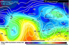
What previous GFS runs have shown is what the current ECM output is showing. The chart below shows this.

ECM 9-1-13 00Z 120Z.JPG

Following the cold snap, a low which formed arond Icleland slip SE towards the UK. This is key as it follows a similar path to the previous one and re-inforces the low over France. This then support the High to the North of us, allowing much colder air to the East to be dragged over us, extending the cold spell.

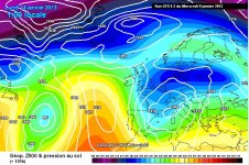
The UKMO shows this to an extent, and does show a longer cold spell

UKMO 9-1-12 00Z 120Z.JPG

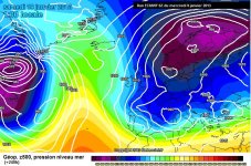
However, the GFS Op run builds a ridge over the UK, which allows the low to miss the UK and progress towards Scandinavia. This kills the block, and the High sinks SE into europe, allowing the Atlantic to reach us a few days later.

GFS 9-1-13 00Z 120Z.JPG


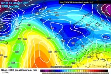
The ECM is a very snowy run all the way through, and ends with this.. an intensely cold blast from the NE

ECM 9-1-13 00Z 240Z.JPG


Papa Lazarou

Living in a De Zerbi wonderland
Jul 7, 2003
19,354
Worthing
but it's FI anyway as its sooo far off.
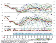
Looking purely at the GFS ensemble FI seems to start at Sunday night.

GFS Worthing Ens 09-01-13 00Z annotated.JPG

The rubbish blue arrow shows the last point where there is decent agreement, after which there is wide divergence in terms of 850hpa and (not shown) surface temps.

I've also added a red circle to highlight the good snow chances over the weekend.


chucky1973

New member
Nov 3, 2010
8,829
Crawley
this all goes over my head!!! But may just get my hat and gloves out for Sunday just in case!!


Papa Lazarou

Living in a De Zerbi wonderland
Jul 7, 2003
19,354
Worthing
this all goes over my head!!! But may just get my hat and gloves out for Sunday just in case!!

Yes, Sunday will be cold.

The latest GFS is a horror show for cold weather. The 'turning point' I mentioned up-thread has turned very much for the worst. The low zips of East, the high collapses, and the Atlantic rushes back in...

The failed cold spell in mid Dec felt very much like this --> GFS goes for cold, sticks to its guns - UKMO comes onboard, ECM comes onbaord for 6 hours --> GFS backtracks immediately, all other models follow.

I'm very very keen to see the GFS ensembles for this, as that will tell just how bad this is for cold and snow next week. :(

Papa, when you say bad, do you mean bad for you snow lovers or bad for us snow haters?


Flex Your Head

Well-known member
I'm very very keen to see the GFS ensembles for this, as that will tell just how bad this is for cold and snow next week. :(
When will you be able take a look at the GFS, Papa?

I've had a bad feeling about this winter ever since we got let down so badly with the 'Beast From the East" which turned out to be a dead chaffinch.


Papa Lazarou

Living in a De Zerbi wonderland
Jul 7, 2003
19,354
Worthing
When will you be able take a look at the GFS, Papa?

I've had a bad feeling about this winter ever since we got let down so badly with the 'Beast From the East" which turned out to be a dead chaffinch.

The short version (Hi Resolution part) is out now.

Meteociel - Diagrammes GEFS

The Op & Control (the 2 highest res runs) are close to mild outliers, which is reassuring, BUT sometimes when these 2 agree on a different evolution it can be the emergence of a new solution.

GFS is currently on it's own, so taking into account the other models I'd say we're still 70/30 in favour of a cold spell from the weekend. The 12Z runs later on will be key. If the other big guns (UKMO & ECM) stick to the cold outlook we're looking good, and of course the GFS may come back to cold.

The very latest UKMO forecast is encouraging:

UK Outlook for Monday 14 Jan 2013 to Wednesday 23 Jan 2013:
Through Monday, outbreaks of rain, sleet and snow are expected to spread southeastwards across central and western areas. Eastern areas will be mostly dry and bright, although with a risk of some coastal wintry showers. By Tuesday, western parts should turn generally dry and fine although some sleet and snow showers are likely to continue towards the east. It will be cold with widespread frost and ice in places. Through the remainder of the period, central and western areas are likely to see generally fine and dry weather with overnight frost and freezing fog, although some rain and milder conditions may spread into the far west at times. Elsewhere, wintry showers are expected, with the risk of snow even to low levels, and these showers may spread westwards at times.
Updated: 1104 on Wed 9 Jan 2013


Albion and Premier League latest from Sky Sports


Top
Link Here