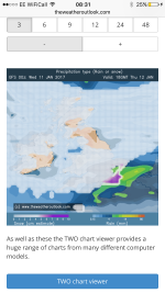
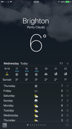
It's going to rain isn't it?
You are using an out of date browser. It may not display this or other websites correctly.
You should upgrade or use an alternative browser.
You should upgrade or use an alternative browser.
[Misc] The Award-winning official "More Snow Tomorrow?" Thread [2024-25 Season]
- Thread starter Giraffe
- Start date
More options
Who Replied?BUTTERBALL
East Stand Brighton Boyz
I remember a huge dump in early 2013 (I think) around rush hour one evening. Coming home from London there was was massive, fairly unexpected snow fall (for the UK at least) and by the time I got back to Brighton there were no buses running and taxis had given up as well. I ended up having to walk from the station back to the other side of Queens Park in the snow wearing leather soled office shoes which was fun. Got to Freshfield Road in the end and there were 3 buses abandoned in the street! The bus in the middle of the picture wasn't overtaking anything, it had been abandoned.
View attachment 81039
I remember that night well. I got stranded in Worthing, had to book into a hotel overnight.
Thunder Bolt
Silly old bat
1-2 cms forecast but could be up to 10 cms in places.
Papa Lazarou
Living in a De Zerbi wonderland
It's going to rain isn't it?
I'm sure it will at some stage - in fact it will probably rain first... it's whether it turns to snow for most that's important. GFS has rain to snow for the whole area Thursday early evening. Other models have just rain.
martin tyler
Well-known member
- Jan 25, 2013
- 5,969
LamieRobertson
Not awoke
BBC forecasts snow for the south Thurs evening rush hour.
If u listen to the forecast they really aren't that certain ..contrary to the graphics....further north they are more confident
Thunder Bolt
Silly old bat
If u listen to the forecast they really aren't that certain ..contrary to the graphics....further north they are more confident
That's why I said forecast rather than predicted. The very nature of forecast is what is thought will happen.
- Aug 8, 2005
- 27,242
- Thread starter
- #10,848
Net weather has just a 24% chance of snow in Findon for Thursday 6-9pm. So I won't be getting my sled out just yet.
Just 16% for Brighton.
Looks unlikely to happen to me (trying to set my own expectations here!).
Just 16% for Brighton.
Looks unlikely to happen to me (trying to set my own expectations here!).
LamieRobertson
Not awoke
That's why I said forecast rather than predicted. The very nature of forecast is what is thought will happen.
Agreed...but they've forecast with caveats
Cheshire Cat
The most curious thing..
Got a weather warning for snow up here on the Met Office site
http://www.metoffice.gov.uk/public/weather/warnings/#?tab=warnings®ionName=nw&fcTime=1484179200
http://www.metoffice.gov.uk/public/weather/warnings/#?tab=warnings®ionName=nw&fcTime=1484179200
larus
Well-known member
Surely we're only meant to be getting SW'ly all winter as the Oracle has spoken 
jakarta
Well-known member
All I can say is that it is blimmin cold over here in Chavland (Colchester) this evening & their local forecast is for snow late afternoon.
Luckily I'm doing the early (6-2) shift so should be on my way back to Sussex by the time it arrives.
Luckily I'm doing the early (6-2) shift so should be on my way back to Sussex by the time it arrives.
chucky1973
New member
Papa. Gives news sir. Beeb say snow. But what do your models and pretty pictures say?
clippedgull
Hotdogs, extra onions
chucky1973
New member
It's not looking very promising now is it.
In the last few years it's only this thread I look on for snow updates. I'm hoping that papa gives us good news.
Papa Lazarou
Living in a De Zerbi wonderland
In the last few years it's only this thread I look on for snow updates. I'm hoping that papa gives us good news.
The most likely scenario is rain turning to snow by 5:30-6:00pm tomorrow. A little elevation will help.
Friday morning still looks like another opportunity, which have the advantage of being after a cold night.
I know it risks clouding the next couple of days but there is still a good chance that by early next week we'll be under the influence of a cold high pressure. The precise positioning is key and some output puts it to our NE allowing cold air to reach the South particularly and an increasing chance of snow later in the week.
The ECM continues to support this including pulling in some very cold air off the near continent.
Here's hoping for something snowy tomorrow.
Good night
chucky1973
New member
The most likely scenario is rain turning to snow by 5:30-6:00pm tomorrow. A little elevation will help.
Friday morning still looks like another opportunity, which have the advantage of being after a cold night.
I know it risks clouding the next couple of days but there is still a good chance that by early next week we'll be under the influence of a cold high pressure. The precise positioning is key and some output puts it to our NE allowing cold air to reach the South particularly and an increasing chance of snow later in the week.
The ECM continues to support this including pulling in some very cold air off the near continent.
Here's hoping for something snowy tomorrow.
Good night
Good night papa. And thanks. But an early start with an update!!!!!!!!
The most likely scenario is rain turning to snow by 5:30-6:00pm tomorrow. A little elevation will help.
Friday morning still looks like another opportunity, which have the advantage of being after a cold night.
I know it risks clouding the next couple of days but there is still a good chance that by early next week we'll be under the influence of a cold high pressure. The precise positioning is key and some output puts it to our NE allowing cold air to reach the South particularly and an increasing chance of snow later in the week.
The ECM continues to support this including pulling in some very cold air off the near continent.
Here's hoping for something snowy tomorrow.
Good night
See you on The Gallops!
Papa Lazarou
Living in a De Zerbi wonderland
Good night papa. And thanks. But an early start with an update!!!!!!!!
See you on The Gallops!
Steady as she goes really. The outlook is much the same. We need to get through quite a bit if rain and milder weather today before the colder air is able to come to bear. So, don't expect snow to settle everywhere, as surfaces will be wet.
Tomorrow morning still looks interesting with another chance of snow. After that the chance of a block located near Scandinavia is still now likely, so expect to see hints in the TV forecasts, as that would at the very least bring much colder (and drier) air over the South, with a chance of showers or longer spells of snow later.


