You are using an out of date browser. It may not display this or other websites correctly.
You should upgrade or use an alternative browser.
You should upgrade or use an alternative browser.
[Misc] The Award-winning official "More Snow Tomorrow?" Thread [2024-25 Season]
- Thread starter Giraffe
- Start date
More options
Who Replied?Papa Lazarou
Living in a De Zerbi wonderland
I have two meetings in Birmingham tomorrow that could probably be handled by conference call. I'm guessing the conference call would be a better idea than attempting to travel there and back!?
BBC are predicting SNOWMAGEDDON on Thursday. Interesting that so many on this thread usually predict the opposite of what they're saying.
I'd avoid making that journey if I were you.
dibsy
Active member
Different kind of snowflakes in London this morning. Floating about in the air, not settling yet.
It's dry snow according to the radio this morning. Good for sledding, rubbish for snowballs.
Snowflakes starting to appear in Horsham, the Daily Mail readers' eyes are popping out in fury
Made my normal commute around the western M25 (up the A22 from Uckfield, M25 around to M4 for a quick blast, then north to Uxbridge). No snow until I got to the M25, from there it was variable. Not settling appreciably until I got to Uxbridge - primarily because the snow, while large clumpy stuff, is so dry and light that it just gets blown away from any surfaces that aren't sheltered.
Going to be keeping an eye on the weather radar all day, as there's some stretches of the A22 that could get tricky if it starts to build up.
Going to be keeping an eye on the weather radar all day, as there's some stretches of the A22 that could get tricky if it starts to build up.
Plake
Unregistered User
Blizzard over Rampion about 8 miles offshore from Marina. Photo taken while stationary at lights with engine off, officer.


LamieRobertson
Not awoke
The 'feels like' temperatures for Wednesday/Thursday are a tad chilly
LamieRobertson
Not awoke
Blizzard over Rampion about 8 miles offshore from Marina. Photo taken while stationary at lights with engine off, officer.

Ye but whats happened tot he road....i thought it was flat
Snowflakes in Crawley now
Brighton is full of snowflakes!
Papa Lazarou
Living in a De Zerbi wonderland
We didn't finalise an approved Flumpdex....
I propose a 5 level scale - like Hurricanes.
Level 5 = Flumping
Level 4 ?
Level 3?
Level 2?
Level 1 = Flurries
I propose a 5 level scale - like Hurricanes.
Level 5 = Flumping
Level 4 ?
Level 3?
Level 2?
Level 1 = Flurries
Thunder Bolt
Silly old bat
Brighton is full of snowflakes!
That i agree with
martin tyler
Well-known member
- Jan 25, 2013
- 6,033
Level 1 in Firle
gripper stebson
Well-known member
- Jul 27, 2004
- 6,699
We didn't finalise an approved Flumpdex....
I propose a 5 level scale - like Hurricanes.
Level 5 = Flumping
Level 4 ?
Level 3?
Level 2?
Level 1 = Flurries
Level 5 = Flumping
Level 4 = Flurmping
Level 3 = Flurming
Level 2 = Flurmies
Level 1 = Flurries
larus
Well-known member
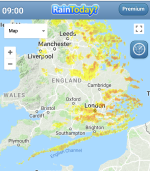
The snow is pepping up north of Crawley and into London now. Snowing lightly in Croydon and a covering plus what looks like a coastal streamer developing along the Kent and East Sussex coast
I'd expect the snow to expand and develop today.
Later today the snow showers will get heavier, so overnight could be interesting.
I still think the Thursday to Friday event will end wet and less Cold, but these is still some hope for it to stay Cold, but I'd only say about 10% chance at the moment
The models appear to to be splitting that Iberian low and taking the main part west of Ireland, and another part east through the channel, keeping the cold air in and increased chance of serious flumpage here. (Usual caveats about the models can change etc.).
Brighthelmstone
Well-known member
Seems even snow doesnt want to visit Burgess Hill! 
Tom Hark Preston Park
Will Post For Cash
- Jul 6, 2003
- 73,293
The models appear to to be splitting that Iberian low and taking the main part west of Ireland, and another part east through the channel
Splitters!
Thunder Bolt
Silly old bat
It's stopped now but the snowflakes that have fallen, haven't melted. It's quite pretty seeing whole snowflakes laying on top of the wheelie bin.
Blue skies at the moment, but clouds on the eastern horizon.
Starting again but just level 1 flurries.
Papa Lazarou
Living in a De Zerbi wonderland
The models appear to to be splitting that Iberian low and taking the main part west of Ireland, and another part east through the channel, keeping the cold air in and increased chance of serious flumpage here. (Usual caveats about the models can change etc.).
Still far too much of a mess to call it either way. I'd rather err on the side of disappointment for now, and IF it stays cold, well that's a bonus.

