Got something to say or just want fewer pesky ads? Join us... 😊

[Misc] The Award-winning official "More Snow Tomorrow?" Thread [2024-25 Season]


Withdean11

Well-known member
Feb 18, 2007
2,908
Brighton/Hyde
A good example the possible streamer locations is from today's GFS... Monday lunchtime with a streamer across the SE corner, and another punching into the Midlands.

78-779UK_zsc6.GIF


By Tuesday Morning there are 2 distinct areas across the UK, one down here and another over Northern Eng / S Scotland / N Wales.

96-779UK_qdg3.GIF


By Wednesday we see (on this run a more straight Easterly) and we're in a dry slot, with streams aplenty dotting around the British Isles... over land AND sea. We're in very unstable air here.

126-574UK_zmt7.GIF


And finally, Friday we get the low pressure to the South, and more organised snow possible over the South

174-779UK_pkf9.GIF

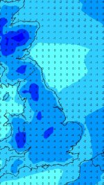
I may be reading this wrong, but is that saying we should be getting no more than 5mm over a 6 hour period? Bit of a non-event then?


spongy

Well-known member
Aug 7, 2011
2,780
Burgess Hill
Is this REALLY going to happen? I'm moving house next thurs/fri/sat. I CAN'T have snow. It'll be the end of me. I'm bloody stressed enough as it is.


Djmiles

Barndoor Holroyd
Dec 1, 2005
12,064
Kitchener, Canada
Is this REALLY going to happen? I'm moving house next thurs/fri/sat. I CAN'T have snow. It'll be the end of me. I'm bloody stressed enough as it is.

I don’t like your chances...


martin tyler

Well-known member
Jan 25, 2013
5,968
Is this REALLY going to happen? I'm moving house next thurs/fri/sat. I CAN'T have snow. It'll be the end of me. I'm bloody stressed enough as it is.

Ouch. Thursday/Friday is marginal but som models really showing a snow flumpage. Could get messy


Giraffe

VERY part time moderator
Helpful Moderator
NSC Patron
Aug 8, 2005
27,237
As I have said, it's hard to make precise forecasts as the initial snow will be from showers or streamers, so how far inland these penetrate will depend upon:

The wind strength - stronger winds push showers inland quicker before they decay
The air temperature - the colder air will encourage greater instability creating showers over the sea
The sea temperature - the difference between the air temp and the sea temp contributes to the instability of the air
The 'fetch' of the wind - so how far it has to pass over the sea and pick up moisture

This allows streamers and coastal showers to be created, so Mon / Tues / Wed I would expect places such as the East coast (England, Ireland and Scotland) will see almost continual snow showers, so some places could see feet of snow, drifting in the wind. The streamers are what inland areas will rely on initially, as we saw in 2010 here with semi-permanent rows of showers across the SE. These WILL form, but the last variable will determine where these 'point'...

The wind direction - Here, we need something between NE and ENE ideally, as that gives will create streamers off the south North Sea, and Thames Estuary and hit us. For The Midlands I'd expect these features to hit Tuesday / Wednesday, but there WILL be gaps and areas that get missed. So, it will depend on all the variable as to how 'deep' the showers penetrate and where they hit. Same for the West Country.

One final point, for Sussex, we don't really want a direct Easterly without any enhanced features the journey across the Dover Straits will be too short, and we'd get bone dry but cold air.

The next thing to consider is the development of trough lines and enhanced features in the flow. These have the effect of increasing the snow / shower intensity and will allow snow to penetrate further inland. These will show up on the synoptic charts as kinks in the isobars to denote subtle low pressure features, and will appear on the radar as more organised snow.

The last variable is the involvement of low pressure systems nudging in from the South, which all models play with. With the cold air over us, any low passing to our south will throw up a band of snow, which if correctly positioned could give increased Easterly winds and heavy snow. This could affect many of us, if it happens. This is the possible outcome Thursday into Friday.

I have to say regardless of whether we actually get any snow or not I am loving your analysis. Very clear and understandable.

It deserves some white stuff as a reward! The cold and wet kind.


Papa Lazarou

Living in a De Zerbi wonderland
Jul 7, 2003
19,365
Worthing
I have to say regardless of whether we actually get any snow or not I am loving your analysis. Very clear and understandable.

It deserves some white stuff as a reward! The cold and wet kind.

Not wet. Powder (snow) would be perfect at least to start.


vegster

Sanity Clause
May 5, 2008
28,273
That's 5mm of rain equivalent, which on average will give 5cm of snow.

I remember once being told 1" rain = 6" snow ... is that right .. ish ?


Djmiles

Barndoor Holroyd
Dec 1, 2005
12,064
Kitchener, Canada
I remember once being told 1" rain = 6" snow ... is that right .. ish ?

Generally 1mm of rain is 1cm of snow. I think.


vegster

Sanity Clause
May 5, 2008
28,273
Well, on average, it works out as 1:10 rain: snow, so 1 inch = 10 inches, so not quite a foot.

Thanks, quite a good return then for a bit of rain :thumbsup:


vegster

Sanity Clause
May 5, 2008
28,273
Not sure yet. I have emptied Waitrose of Pot Noodles and Big Soups tonight.

Chicken and Vegetable Big Soup with a pinch of chilli flakes is antifreeze for humans.


Albion and Premier League latest from Sky Sports


Top
Link Here