Got something to say or just want fewer pesky ads? Join us... 😊

[Misc] The Award-winning official "More Snow Tomorrow?" Thread [2024-25 Season]


Frutos

.
Helpful Moderator
NSC Patron
May 3, 2006
36,295
Northumberland
Re: The award-winning official "More snow tomorrow?" thread [2012-13 season]

Snow has resumed in Burgess Hill.


Papa Lazarou

Living in a De Zerbi wonderland
Jul 7, 2003
19,354
Worthing
''Cough, Cough''

This was hardly a proper fall of snow, but it did snow :)

This was always in the output, but even up to 11pm last night was only a 40% chance of occuring. It took a combination of ideal conditions to get this.

As I've mentioned up thread, there's a strong signal for a proper cold spell at some point, but I'm waiting for some convergence in the model output before I flag it on here, as we all know what happens to people who 'Cry Snow'.

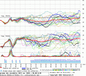
To give a flavour of the signal and the uncertainty, you only need to look at this morning's GFS ensemble output:

Worthing GFS 00Z 05-12-12.GIF

There's a lot of cold runs in there, and a run on 25%-40% snow chances from 12th onwards, but there's still a lot of divergence.

At a larger scale there's no cross model support.

The GFS, ECM and other minor models support the establishment of a large high pressure over Eastern Scandinavia, and initially a slack easterly feed, but with this intensifying as low pressure moves into position to our S/SW.

However, the Met Office output doesn't support this, although oddly it has been commented that the Met Office forecasters are favouring the ECM output for forecasting purposes.

I feel that within the next 24-48 hours we'll either see complete agreement on something special in the run up to Xmas, or a massive back-track from ECM / GFS.

It's all to play for...


SK1NT

Well-known member
Sep 9, 2003
8,762
Thames Ditton
Snowed heavily and settled a bit in Kingston.

I didn't hear a thing about expected snow. Was it forecast?


Papa Lazarou

Living in a De Zerbi wonderland
Jul 7, 2003
19,354
Worthing
I think Papa is on about longer term.

One the plus side, the current models show there will be a High Pressure blocker above Scandinavia for most of next week.

Aye... just need to UKMO to come onboard, and we can unleash the Beast From The East.... and signal the start of Snowmaggedon :)


Badger

NOT the Honey Badger
NSC Patron
May 8, 2007
13,101
Toronto
Aye... just need to UKMO to come onboard, and we can unleash the Beast From The East.... and signal the start of Snowmaggedon :)

Haven't you read the Daily Mail? Apparently this winter is going to be like a new ice age, it HAS to be true as The Daily Mail would NEVER exaggerate such a claim or post a 'non-story'.


BigGully

Well-known member
Sep 8, 2006
7,139
I think Papa is on about longer term.

One the plus side, the current models show there will be a High Pressure blocker above Scandinavia for most of next week.

No he wasnt he was saying nothing was likely now or in the foreseeable future according to the model outputs, although there are some indications of a colder outcome.

Its just how the weather can sometimes surprise even the most ardent and knowledgeable of meteorologists.

It really wasnt a dig just a little poke in his ribs with a wry smile ;-)


Papa Lazarou

Living in a De Zerbi wonderland
Jul 7, 2003
19,354
Worthing
No he wasnt he was saying nothing was likely now or in the foreseeable future according to the model outputs, although there are some indications of a colder outcome.

Its just how the weather can sometimes surprise even the most ardent and knowledgeable of meteorologists.

It really wasnt a dig just a little poke in his ribs with a wry smile ;-)
Point taken... If you want to know about every posible snow chance - keep a watch on the forecast for Friday morning... it's possible we might get something then, but it's going to start as rain, so the ground will start wet.


Papa Lazarou

Living in a De Zerbi wonderland
Jul 7, 2003
19,354
Worthing
As if to to illustrate my earlier point about the convergence of the model output:

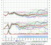
The latest (6hour) output has a much closer agreement on a spell of cold weather:

Worthing GFS 06Z 05-12-12.GIF

This shows the same view as before, with the majority of the runs going cold, and an increased chance of snow (section circled)

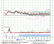
Worthing 2m Temp GFS 06Z 05-12-12.GIF

This view shows the 2M temperature (top line) which is showing most runs going for a period of sustained temps in the 0-3C range, with some very cold options on there. (see sections circled in red)

Please remember, this is a plot for Worthing, so further East would have more precipitation in this setup, and further inland (and NE) would be colder.


Papa Lazarou

Living in a De Zerbi wonderland
Jul 7, 2003
19,354
Worthing
Does any of this apply "up north"?

Yes, just not quite as I've shown above. If we get a NE flow, usually pressure is higher to the NW, so precipitation further north may be limited to the East Coast. It's a NE flow, based around a Scandi or Icelandic (or both) High that gives us down here our best snowfall, as there short distance across the channel / southern North Sea allows little warming of the air, but allows enough moisture to be picked up (and just enough modification) to produce lots of showers, and even streamers into the SE and CS England.

In this setup the East Coast would also get snow showers, and some may penetrate inland.

We'd also be on the lookout for small scale but potent features developing in the flow which would produce more organised precipitation, but this would still be heaviest near the windward coast.

Northern areas, especially Manchester tend to fare better in a northerly flow.

Editted to add:

One element I didn't mention was the arrival of a low pressure system from the West. In a Scandi block situation when this occurs you can get some of the most spectacular snow falls for places such as the SW, along the south coast and up into the Midlands (all dependant upon the exact track of the low).

This is cause by the low being forced W->E along the southern edge of the block, and (hopefully) establishing strong Easterly winds, with the milder air (which most depressions include) being kept to the south.

Most of the major snow-falls in the SW of England have been from such a scenario.
 
Last edited:


The Wizard

Well-known member
Jul 2, 2009
18,399
Something big coming in from the east next week, and when we have a flow from the east we are always favoured down here as troughs(features that bring snow in a setup that is forecast) always undercut the block over Scandinavia and head over us. Still not set in stone but I have a reasonable confidence, 75% that we will see a flow from the east with potential for snow and day time temperatures struggling to get above 1c. I'm not Papa I know, but thats my view on it all.

@Papa - Are you by any chance registered on here?

http://forum.netweather.tv


shaolinpunk

[Insert witty title here]
Nov 28, 2005
7,187
Brighton
I'm not going to lie, when it comes to wintry weather this thread is my first port of call ahead of any official weather source.


Vegas Seagull

New member
Jul 10, 2009
7,782
The award-winning official "More snow tomorrow?" thread [2012-13 season]

Yes, just not quite as I've shown above. If we get a NE flow, usually pressure is higher to the NW, so precipitation further north may be limited to the East Coast. It's a NE flow, based around a Scandi or Icelandic (or both) High that gives us down here our best snowfall, as there short distance across the channel / southern North Sea allows little warming of the air, but allows enough moisture to be picked up (and just enough modification) to produce lots of showers, and even streamers into the SE and CS England.

In this setup the East Coast would also get snow showers, and some may penetrate inland.

We'd also be on the lookout for small scale but potent features developing in the flow which would produce more organised precipitation, but this would still be heaviest near the windward coast.

Northern areas, especially Manchester tend to fare better in a northerly flow.

Good analysis Papa, do you use this data for any monetary wagers at all? I ask because last year I picked up £300 betting on the coldest day of the winter in the UK (Dec 1-28Feb) and its remarkably early occurrence on Dec 2nd & would like your views on whether your charts on 12-15 Dec have a chance of a significant low to -15c or thereabouts (invariably overnight in the Highlands is the 'winner')
Cheers


CliveWalkerWingWizard

Well-known member
Aug 31, 2006
2,689
surrenden
I wish someone would decide whether the forest game is on or not - I hate it when they leaveit to the last minute:lol:


Albion and Premier League latest from Sky Sports


Top
Link Here