Got something to say or just want fewer pesky ads? Join us... 😊

[Misc] From the Adur Centre in Shoreham...


Bozza

You can change this
Helpful Moderator
Jul 4, 2003
57,283
Back in Sussex
1. Is it possible to go north along the west bank of the Adur, ie go around the airport and under the A27 etc?

2. Is the South Downs Way the only place to cross over the Adur?

3. What's it likely to be underfoot along there currently?

(I need to take my son to the AC to go climbing so thinking of taking my run up along the river to kill time)

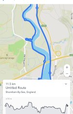
Something like this: https://footpathapp.com/routes/390790FE-0DF8-437E-BDC5-BD0551FC86E2


Beach Hut

Brighton Bhuna Boy
Jul 5, 2003
72,312
Living In a Box
1. Is it possible to go north along the west bank of the Adur, ie go around the airport and under the A27 etc?

Go on East side

2. Is the South Downs Way the only place to cross over the Adur?

There is a bridge further up and you could run back via Botolphs/Lancing College

3. What's it likely to be underfoot along there currently?

There is a proper path, I cycle it sometimes


The Clamp

Well-known member
NSC Patron
Jan 11, 2016
26,182
West is BEST
If I’ve understood where you’re going, the only place you can’t get access to right now is Cuckoos Corner. It’s closed off for some reason. It was rather muddy underfoot yesterday along both banks.
You could run along the raised airport track, cross over the Toll bridge, turn left and run along the Downs Link before crossing over the road and take the steep up to Mill Hill, run west along then country road, across the bridge, drop down to The Amsterdam pub and join the Downslink again to take you into ropetackle, cross the Norfolk Bridge back to AC.

Is he climbing on the outdoor boulder or is there an inside wall?


Bozza

You can change this
Helpful Moderator
Jul 4, 2003
57,283
Back in Sussex
If I’ve understood where you’re going, the only place you can’t get access to right now is Cuckoos Corner. It’s closed off for some reason. It was rather muddy underfoot yesterday along both banks.
You could run along the raised airport track, cross over the Toll bridge, turn left and run along the Downs Link before crossing over the road and take the steep up to Mill Hill, run west along then country road, across the bridge, drop down to The Amsterdam pub and join the Downslink again to take you into ropetackle, cross the Norfolk Bridge back to AC.

Is he climbing on the outdoor boulder or is there an inside wall?

Where is Cuckoos Corner? This whole area is a bit of a mystery to me.

There is an indoor climbing wall, I believe. He's going with the scouts.


LamieRobertson

Not awoke
Feb 3, 2008
48,398
SHOREHAM BY SEA
If I’ve understood where you’re going, the only place you can’t get access to right now is Cuckoos Corner. It’s closed off for some reason. It was rather muddy underfoot yesterday along both banks.
You could run along the raised airport track, cross over the Toll bridge, turn left and run along the Downs Link before crossing over the road and take the steep up to Mill Hill, run west along then country road, across the bridge, drop down to The Amsterdam pub and join the Downslink again to take you into ropetackle, cross the Norfolk Bridge back to AC.

Is he climbing on the outdoor boulder or is there an inside wall?

What he said


Beach Hut

Brighton Bhuna Boy
Jul 5, 2003
72,312
Living In a Box
I would avoid the West Bank as was closed recently by Ricardos and as stated probably muddy however if you have to use the road via Lancing College


The Clamp

Well-known member
NSC Patron
Jan 11, 2016
26,182
West is BEST
Where is Cuckoos Corner? This whole area is a bit of a mystery to me.

There is an indoor climbing wall, I believe. He's going with the scouts.

It’s on the other side of the river that you want so it won’t affect you. It’s where the river clefts and you have to cut into a car park to continue. If you’re running along the other side, you have unhindered access.

You could also use the raised airport path, turn left and cross the A27 on ground level, through past the Little Lancing nursery school and up the path that leads to the Equestrian centre with lancing College on your right, right turn up to lancing ring, round the ring and back down the same way.

I think the Mill Hill route is a better run though.

Hope he has a good climb. If he’s into it, I recommend Boulder Brighton in Southwick. Really good centre. I’ve been going there a while and always enjoyed it.


Bozza

You can change this
Helpful Moderator
Jul 4, 2003
57,283
Back in Sussex
It’s on the other side of the river that you want so it won’t affect you. It’s where the river clefts and you have to cut into a car park to continue. If you’re running along the other side, you have unhindered access.

You could also use the raised airport path, turn left and cross the A27 on ground level, through past the Little Lancing nursery school and up the path that leads to the Equestrian centre, right turn up to lancing ring, round the ring and back down the same way.

I think the Mill Hill route is a better run though.

Hope he has a good climb. If he’s into it, I recommend Boulder Brighton in Southwick. Really good centre. I’ve been going there a while and always enjoyed it.

I'm a bit lost. If you click on my link in the opening post, you'll see my proposed route - up one side, over a bridge and back down the other side.

I think you're suggesting this isnt possible, but I'm not sure quite where/how/why!


Bozza

You can change this
Helpful Moderator
Jul 4, 2003
57,283
Back in Sussex
...I could just run along the coast towards Brighton on the road and then come back, but along the river feels like it would be more fun. I can wear trail shoes to deal with any mud.


The Clamp

Well-known member
NSC Patron
Jan 11, 2016
26,182
West is BEST
E5F03B21-80C3-4CEB-A4A4-DC5EDFB64290.jpeg

You see where Coombes Rd juts out and meets where the Adur juts out? I’m pretty sure that’s Cuckoos Corner and that has been closed all week. So it may still be closed tomorrow. So you may come a cropper there.

If you stick to the other bank, take a left along the Downslink (there’s a map opposite the Shoreham Air Disaster memorial) you can cross over the road, go through a gate that takes a steep up to Mill Hill (the route I mentioned first).

Sorry, I’m not great at explaining it.

If Cuckoos corner is open, the route you posted may be a bit muddy but is a good run and the route is obvious as you run along because you obviously have the river right next to you.


Bozza

You can change this
Helpful Moderator
Jul 4, 2003
57,283
Back in Sussex
View attachment 146726

You see where Coombes Rd juts out and meets where the Adur juts out? I’m pretty sure that’s Cuckoos Corner and that has been closed all week. So it may still be closed tomorrow. So you may come a cropper there.

If you stick to the other bank, take a left along the Downslink (there’s a map opposite the Shoreham Air Disaster memorial) you can cross over the road, go through a gate that takes a steep up to Mill Hill (the route I mentioned first).

Sorry, I’m not great at explaining it.

If Cuckoos corner is open, the route you posted may be a bit muddy but is a good run and the route is obvious as you run along because you obviously have the river right next to you.

Cheers - it's this evening. I'll just give it a go and see what happens!


The Clamp

Well-known member
NSC Patron
Jan 11, 2016
26,182
West is BEST
Cheers - it's this evening. I'll just give it a go and see what happens!

I think you’ll be fine. Run along, find a bridge, cross over, run back. I think you’ll find it very easy to figure out when you get going. Enjoy!


Simgull

Well-known member
Jan 3, 2013
1,669
Hove
Depends how far you want to go but here some routes - you can download these onto a running watch.

The cuckoo's corner path has been closed for some time but you can just use Coombe Road if necessary. I'd recommend going up via LAncing College, Lancing ring and Steep Down such as in the first route here.

10 miles https://gb.mapometer.com/running/route_5246664.html

12 miles https://gb.mapometer.com/running/route_5278386.html

11 miles https://gb.mapometer.com/running/route_5340846.html

You can easily strike out to Cissbury or Chanctonbury from these if you want to go a bit further.

You can park for free at the outdoor centre which is handy.


The Clamp

Well-known member
NSC Patron
Jan 11, 2016
26,182
West is BEST
Depends how far you want to go but here some routes - you can download these onto a running watch.

The cuckoo's corner path has been closed for some time but you can just use Coombe Road if necessary. I'd recommend going up via LAncing College, Lancing ring and Steep Down such as in the first route here.

10 miles https://gb.mapometer.com/running/route_5246664.html

12 miles https://gb.mapometer.com/running/route_5278386.html

11 miles https://gb.mapometer.com/running/route_5340846.html

You can easily strike out to Cissbury or Chanctonbury from these if you want to go a bit further.

You can park for free at the outdoor centre which is handy.


Much better explained than my fumblings!


Stat Brother

Well-known member
NSC Patron
Jul 11, 2003
73,888
West west west Sussex
Can you please hurry up with your running around.
I want to know the fixtures for this weekend.


CheeseRolls

Well-known member
NSC Patron
Jan 27, 2009
6,229
Shoreham Beach
Depends how far you want to go but here some routes - you can download these onto a running watch.

The cuckoo's corner path has been closed for some time but you can just use Coombe Road if necessary. I'd recommend going up via LAncing College, Lancing ring and Steep Down such as in the first route here.

10 miles https://gb.mapometer.com/running/route_5246664.html

12 miles https://gb.mapometer.com/running/route_5278386.html

11 miles https://gb.mapometer.com/running/route_5340846.html

You can easily strike out to Cissbury or Chanctonbury from these if you want to go a bit further.

You can park for free at the outdoor centre which is handy.

I haven't been up this way in recent weeks, but know the route well and I am confused. North from Cuckoos Corner there are two paths, one which meanders along the river bank and one that cuts straight across the fields following the stream that is marked. They both meet up before the bridge and the cement works. Which path is closed?

On the other bank the cycle path following the old railway is best this time of year. In the summer I prefer to divert south of the Cement works. There is a route through fields between the riverbank path and the cycle path.


Simgull

Well-known member
Jan 3, 2013
1,669
Hove
I haven't been up this way in recent weeks, but know the route well and I am confused. North from Cuckoos Corner there are two paths, one which meanders along the river bank and one that cuts straight across the fields following the stream that is marked. They both meet up before the bridge and the cement works. Which path is closed?

On the other bank the cycle path following the old railway is best this time of year. In the summer I prefer to divert south of the Cement works. There is a route through fields between the riverbank path and the cycle path.

If I remember correctly there is a sign by the bridge saying the path (going south)is closed - so possibly both. It looked like some fairly heavy duty engineering equipment in the field - I don’t know any more than that thoug oh and this was a month ago or so..


Albion and Premier League latest from Sky Sports


Top
Link Here